


Fridley W-3 P-1, Anoka County, Minnesota
About
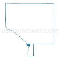
Outline

Summary
| Unique Area Identifier | 601031 |
| Name | Fridley W-3 P-1 |
| County | Anoka County |
| State | Minnesota |
| Area (square miles) | 1.27 |
| Land Area (square miles) | 1.18 |
| Water Area (square miles) | 0.09 |
| % of Land Area | 92.67 |
| % of Water Area | 7.33 |
| Latitude of the Internal Point | 45.11996600 |
| Longtitude of the Internal Point | -93.27336760 |
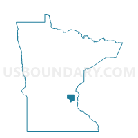
Maps

Graphs
Select a template below for downloading or customizing gragh for Fridley W-3 P-1, Anoka County, Minnesota


Neighbors
Neighoring Voting District (by Name) Neighboring Voting District on the Map
- Blaine D-1 P-4, Anoka County, MN
- Brooklyn Park W-E P-5, Hennepin County, MN
- Coon Rapids W-3 P-4, Anoka County, MN
- Fridley W-1 P-1, Anoka County, MN
- Fridley W-3 P-2, Anoka County, MN
- Spring Lake Park P-3, Anoka County, MN
Top 10 Neighboring County Subdivision (by Population) Neighboring County Subdivision on the Map
- Brooklyn Park city, Hennepin County, MN (75,781)
- Coon Rapids city, Anoka County, MN (61,476)
- Blaine city, Anoka County, MN (57,186)
- Fridley city, Anoka County, MN (27,208)
- Spring Lake Park city, Anoka County, MN (6,234)
Top 10 Neighboring Place (by Population) Neighboring Place on the Map
- Brooklyn Park city, MN (75,781)
- Coon Rapids city, MN (61,476)
- Blaine city, MN (57,186)
- Fridley city, MN (27,208)
- Spring Lake Park city, MN (6,412)
Top 10 Neighboring Unified School District (by Population) Neighboring Unified School District on the Map
- Anoka-Hennepin Public School District, MN (226,412)
- Spring Lake Park Public Schools, MN (29,903)
- Fridley Public School District, MN (15,505)
Top 10 Neighboring State Legislative District Lower Chamber (by Population) Neighboring State Legislative District Lower Chamber on the Map
- State House District 47B, MN (43,813)
- State House District 50A, MN (38,524)
- State House District 51B, MN (35,197)
Top 10 Neighboring State Legislative District Upper Chamber (by Population) Neighboring State Legislative District Upper Chamber on the Map
- State Senate District 51, MN (84,827)
- State Senate District 47, MN (80,760)
- State Senate District 50, MN (74,595)
Top 10 Neighboring 111th Congressional District (by Population) Neighboring 111th Congressional District on the Map
- Congressional District 6, MN (759,478)
- Congressional District 3, MN (650,185)
- Congressional District 5, MN (616,482)
Top 10 Neighboring Census Tract (by Population) Neighboring Census Tract on the Map
- Census Tract 268.22, Hennepin County, MN (5,053)
- Census Tract 511.01, Anoka County, MN (4,985)
- Census Tract 511.02, Anoka County, MN (4,312)
- Census Tract 510.02, Anoka County, MN (3,759)
- Census Tract 507.10, Anoka County, MN (3,489)
- Census Tract 508.11, Anoka County, MN (2,870)
- Census Tract 507.09, Anoka County, MN (2,478)